Our work
We have been in business for more than fourteen (14) years during which we have
dealt with a cocktail of challenges.
Having been involved in a number of projects of varying scope
and size spanning various spatial technology domains, we have captured data, developed software,
trained users and advised clients.
This section highlights a few out of many successful projects we
have been involved in.
UNICEF
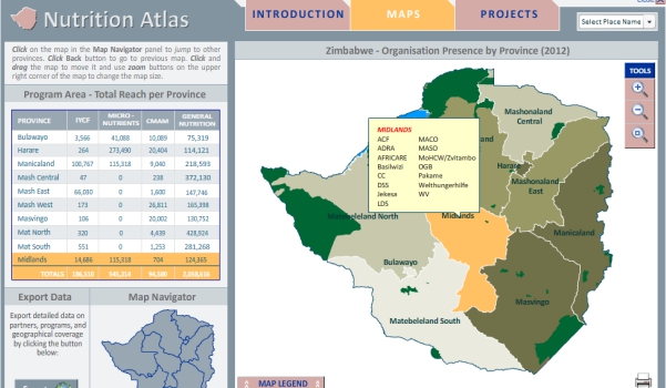
To strengthen its coordination role, UNICEF started in 2005 with the development of sector-specific planning tools, such as the WASH, Nutrition, Education and Multi-Sector Atlas. These Atlases presents a clear overview of 'who is doing what where' and is aimed to improve evidence-based planning and programming as well as coordination of the different interventions areas. Technical Systems has been engaged by UNICEF since 2008 to date to create the interactive map atlases

Government of Cambodia - Ministry of Planning
The Identification of Poor Households (IDPoor) Programme was established in 2006 within the Ministry of Planning to officially establish national procedures for identification of poor households and to realise their implementation throughout Cambodia. The challenge was therefore, to develop an Identification of Poor Households Digital Map Tool to drive socioeconomic development by reducing poverty throughout the country

ECONET Wireless
Creation of a 15m contour data covering the whole country for 3D terrain modelling and line-of-site analysis used by Econet in network planning and line-of-sight analyses. For city centre, 3D building models were to be developed using building heights and then warped onto the terrain model.
Zimbabwe Tourism Authority
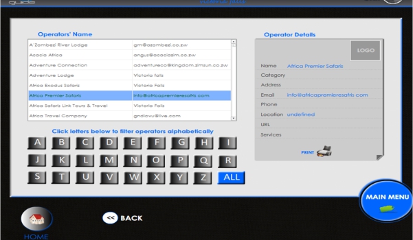
Technical Systems developed the first ever digital touch kiosk tourism display in Zimbabwe. These highlight all the tourism attractions found throughout the country. A user can explore depth knowledge of places of interest, navigate through an entire country map, make bookings and reservations and can contact tour operators using the kiosk. These also serve as digital signage displays which show interactive adverts.
Sierra Leon Government - UNICEF
To strengthen its coordination role, UNICEF started in 2005 with the development of sector-specific planning tools, such as the WASH, Nutrition, Education and Multi-Sector Atlas. These Atlases presents a clear overview of 'who is doing what where' and is aimed to improve evidence-based planning and programming as well as coordination of the different interventions areas. Technical Systems has been engaged by UNICEF since 2008 to date to create the interactive map atlases
Southern Africa Development Community (SADC)
The Identification of Poor Households (IDPoor) Programme was established in 2006 within the Ministry of Planning to officially establish national procedures for identification of poor households and to realise their implementation throughout Cambodia. The challenge was therefore, to develop an Identification of Poor Households Digital Map Tool to drive socioeconomic development by reducing poverty throughout the country.
African Wildlife Foundation
Creation of a 15m contour data covering the whole country for 3D terrain modelling and line-of-site analysis used by Econet in network planning and line-of-sight analyses. For city centre, 3D building models were to be developed using building heights and then warped onto the terrain model.
UNAIDS
Technical Systems developed the first ever digital touch kiosk tourism display in Zimbabwe. These highlight all the tourism attractions found throughout the country. A user can explore depth knowledge of places of interest, navigate through an entire country map, make bookings and reservations and can contact tour operators using the kiosk. These also serve as digital signage displays which show interactive adverts.